


Path of Faith: Excerpts
On this page, the Portal Peregrino da Esperança presents the characteristics and climate of each city along the Caminho da Fé.
🕊️ "Life is like a season of the year, which transforms and renews itself."
Sections of the Águas da Prata branch line to Aparecida
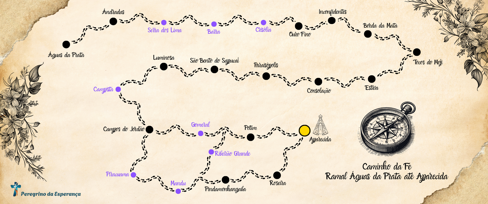
✨ Section 1 - Águas da Prata to Andradas
The initial stretch of the Águas da Prata-Aparecida branch of the Caminho da Fé, which connects the cities of Águas da Prata (SP) to Andradas (MG), is approximately 32 kilometers long and represents one of the most challenging and symbolic stages of the journey. The trail runs through the landscape of the Serra da Mantiqueira, requiring physical fitness and stamina from pilgrims, as it is classified as having a difficult level of difficulty. The altitude varies significantly along the route, with the starting point in Águas da Prata situated at an altitude of approximately 900 meters and points that exceed 1,200 meters, mainly in mountainous stretches and steeper areas, such as near Pico do Gavião.
The climate throughout the year follows the typical characteristics of high-altitude regions. During the winter, between June and August, temperatures are mild during the day, but can drop considerably in the early hours of the morning, making the beginning of the hikes colder. In the summer, from December to February, the heat is more intense and rain is frequent, making the ground slippery and the trail more demanding. Spring and autumn offer more balanced conditions, with mild weather and less risk of bad weather. With dirt roads, winding trails and stretches of forest, this first contact with the Caminho da Fé invites the pilgrim to a deep connection with nature and with themselves, marking the beginning of a journey that is both spiritual and physical.
✨ Section 2 - Andradas to Serra dos Lima
The stretch of the Caminho da Fé between Andradas and Serra dos Lima, approximately 16 kilometers long, takes pilgrims through a typical rural landscape of southern Minas Gerais, marked by gentle hills, cultivated areas and stretches shaded by native vegetation. With a moderate level of difficulty, this segment has less rugged terrain than the previous stretch, but still requires endurance due to the distance and variations in altitude. The altitude varies between 930 meters, at the exit from Andradas, and around 1,100 meters at the arrival at Serra dos Lima, with long climbs and gentle descents that require constant physical preparation throughout the route.
The region's climate directly influences the experience of the hike. During the winter, between June and August, temperatures are low in the early hours of the day, with a chance of fog, but they become more pleasant throughout the morning, making progress easier. In the summer, from December to February, the intense heat and frequent rain can make the journey difficult, making the ground muddy and slippery. The intermediate seasons, such as spring and autumn, have more stable weather and are recommended for a more relaxed crossing. This stretch, although less physically challenging than the previous ones, is essential for building the discipline and inner focus that sustain the pilgrim's walk to Aparecida.
✨ Section 3 - Serra dos Lima to Barra
The stretch of the Caminho da Fé between Serra dos Lima and Barra is approximately 6 kilometers long and is characterized by gently undulating terrain, which offers pilgrims a moderate level route. Although less demanding compared to more mountainous stretches, the walk requires attention and physical fitness, especially due to the constant ups and downs along the dirt roads. The altitude varies between 900 and 1,100 meters, with elevation gains gradually distributed, which makes the route accessible, but not without effort, especially on very hot days or after rain that makes the path slippery.
The climate in the region follows a tropical pattern of altitude, with dry, cold winters and hot, rainy summers. Between June and August, pilgrims will find milder temperatures during the day, ideal for hiking, despite the intense cold in the early hours of the morning. Between December and February, increased rainfall can make the ground muddy and require more caution on the downhill stretches. Spring and autumn have more balanced weather conditions, and are the most recommended seasons for this route. The route between Serra dos Lima and Barra offers pilgrims moments of introspection and silence, surrounded by agricultural landscapes and the simplicity of the local communities, reinforcing the spiritual and contemplative nature of the journey.
✨ Section 4 - Barra to Crisólia
The stretch of the Caminho da Fé between Barra and Crisólia is approximately 14 kilometers long and represents a stage that alternates moments of tranquility with stretches of greater physical demand. The level of difficulty is considered moderate to difficult, due to the presence of long climbs and descents that require attention, especially in adverse weather conditions. The altitude of the route varies between 950 meters, at the exit from Barra, and more than 1,200 meters at the highest points, which requires the pilgrim to make a continuous effort throughout the route. The trail crosses rural areas with landscapes that mix plantations, native forest and stretches of dirt road, creating a setting that encourages introspection and connection with the environment.
The region's climate directly influences the pace of the hike. In winter, lower temperatures, especially in the mornings, make the physical effort more bearable, although the intense cold can be uncomfortable at the beginning of the day. During the summer, the heat and humidity increase the level of difficulty, as frequent rain makes the terrain slippery and slower to overcome. Spring and autumn offer more balanced weather conditions, making them ideal for this crossing. Arriving at Crisólia, after overcoming the elevations and natural challenges of the route, gives the pilgrim a sense of achievement and inner strength, fundamental elements in building the spiritual experience that defines the Caminho da Fé.
✨ Section 5 - Chrysolia to Ouro Fino
The stretch of the Caminho da Fé between Crisólia and Ouro Fino is approximately 6 kilometers long and is characterized by a route of variable altitude, with a predominance of gentle descents and some intermediate climbs. Starting at an altitude of around 1,150 meters in Crisólia and reaching approximately 990 meters in Ouro Fino, the route runs along dirt roads that cross cultivated areas, pastures and small forests, creating a peaceful and welcoming landscape. The level of difficulty is classified as moderate, because although there are no major elevations, the distance and the variations in the terrain require attention and physical endurance, especially on hot days or when the ground is wet.
The climate of the region, typical of the high-altitude areas of southern Minas Gerais, varies throughout the year and directly influences the pilgrim's experience. In winter, temperatures are lower, especially in the early hours of the day, with fog and dry air, favoring physical effort during the walk. In summer, the heat intensifies and rain is more frequent, increasing the difficulty in dirt stretches and making the trail slippery. The spring and fall seasons offer milder and more stable weather, ideal for the crossing. Upon reaching Ouro Fino, the pilgrim finds a city with a strong religious tradition, which welcomes the walker with structure and tranquility, providing a moment of rest and renewal in the middle of the long journey to Aparecida.
✨ Section 6 - Ouro Fino to Inconfidentes
The stretch of the Caminho da Fé between Ouro Fino and Inconfidentes is approximately 10 kilometers long and is considered moderate. It is a shorter stage, but with variations in terrain that require constant attention and physical preparation. The altitude of the route varies between 990 meters in Ouro Fino and approximately 870 meters in Inconfidentes, alternating between gentle climbs and descents on well-maintained dirt roads, with beautiful rural landscapes consisting of plantations, hills and small properties. Although it is not a long stage, the stretch can be more demanding on sunny or rainy days, when the terrain can become slippery and the heat can increase the physical effort.
The climate throughout the year follows the typical pattern of southern Minas Gerais, with dry and cold winters that favor daytime walking, although mornings can be marked by low temperatures and fog. In summer, the heat and rain showers make the path more challenging, especially in clayey areas. Spring and autumn offer the best weather conditions, with mild temperatures and less risk of instability. Arriving in Inconfidentes represents a moment of pause and welcome in a city with a peaceful profile, which welcomes pilgrims with simplicity and hospitality, offering the opportunity to rest and replenish themselves physically and spiritually before the next stages of the journey towards Aparecida.
✨ Section 7 - Inconfidentes to Borda da Mata
The stretch of the Caminho da Fé between Inconfidentes and Borda da Mata is approximately 20 kilometers long and is considered easy to moderate, being one of the shortest and most accessible stages of the Águas da Prata-Aparecida branch. The route begins in Inconfidentes, at approximately 870 meters above sea level, and follows well-defined rural paths, with gentle variations in the terrain until reaching Borda da Mata, also located at approximately 870 meters, maintaining a relatively constant altitude. The dirt roads, combined with the short distance, allow for a more relaxed walking pace, favoring both physical rest and contemplation of the Minas Gerais landscape marked by coffee plantations, pastures and small communities that welcome pilgrims with simplicity.
The climate in the region, typical of southern Minas Gerais, features dry and cold winters, ideal for walking during the day, with cold mornings that require light clothing. In the summer, high temperatures and scattered rains can make the ground slippery, although the short length of the stretch allows you to complete the daily journey with less exposure to these risks. Spring and fall are the best seasons, with mild temperatures and stable conditions. Arriving at Borda da Mata marks the reunion with a city with a religious and welcoming tradition, offering pilgrims basic infrastructure and a peaceful environment, ideal for recovering energy and continuing strengthened on the spiritual journey towards Aparecida.
✨ Section 8 - Edge of the Forest to Tocos do Moji
The stretch of the Caminho da Fé between Borda da Mata and Tocos do Moji is approximately 18 kilometers long and is considered moderate to difficult, especially due to the sequence of continuous climbs that appear along the route. Altimetry is a notable factor in this stage, with Borda da Mata located at around 870 meters above sea level and Tocos do Moji reaching altitudes close to 1,230 meters, which requires the pilgrim to be physically fit and maintain a steady pace to overcome the elevation gains. The trail crosses a beautiful region of rural landscapes, with vast areas of vegetation, crops and stretches of native forest, creating a landscape that alternates between physical effort and contemplation.
The climate of the region follows the pattern of the mountainous areas of southern Minas Gerais, with dry and cold winters, when the walk becomes more comfortable during the day, although the early morning is marked by low temperatures and, at times, fog. In the summer, between December and February, the heat and humidity make the effort more intense, in addition to the dirt ground becoming more slippery due to frequent rains. The best times to walk this stretch are spring and autumn, when temperatures are milder and weather conditions are more stable. Arriving at Tocos do Moji represents the end of a demanding stage, in which the pilgrim is rewarded not only by overcoming physical fatigue, but also by the natural beauty and hospitality of the small town that welcomes hikers with faith and simplicity.
✨ Section 9 - Moji Stumps to Estiva
The stretch of the Caminho da Fé between Tocos do Moji and Estiva is approximately 22 kilometers long and is considered one of the most demanding on the Águas da Prata-Aparecida branch. The altitude varies significantly, with the starting point in Tocos do Moji located at an altitude of approximately 1,230 meters and several uphill and downhill stretches along the way, reaching points close to 1,300 meters before descending to approximately 900 meters upon arrival in Estiva. This alternation of terrain gives the route a high level of difficulty, requiring physical fitness, constant attention and endurance on the part of the pilgrim. The route, mostly on dirt roads and trails, passes through forested areas, pastures and small rural properties, providing moments of natural beauty and profound silence.
The region's climate directly influences the pilgrim's experience, with cold, dry winters, ideal for walking during the day, although mornings can start with low temperatures and fog. Summer, between December and February, brings frequent rain and intense heat, which can make progress difficult, especially on stretches with clayey and steep soil. Spring and fall are the best times for this stretch, with mild temperatures and less chance of climate instability. Arriving in Estiva, after overcoming the challenges of terrain and distance, represents an important point of achievement on the journey, where the physical effort is compensated by the feeling of spiritual advancement and the hospitality typical of the cities in the interior of Minas Gerais.
✨ Section 10 - Estiva to Consolação
The stretch of the Caminho da Fé between Estiva and Consolação is approximately 19 kilometers long and is marked by a moderate to difficult level of difficulty, with long climbs and descents that follow the rugged terrain of the region. The altitude varies considerably along the route, with Estiva located at an altitude of approximately 900 meters and points along the route that exceed 1,200 meters before the descent to Consolação, which is approximately 1,100 meters. This constant fluctuation in the terrain requires physical endurance from the pilgrim and special attention on the steepest stretches, especially on rainy days, when the dirt terrain can become slippery and require greater muscular effort.
The climate is typical of southern Minas Gerais, with dry, cold winters that are ideal for daytime walking, although foggy mornings and low temperatures require appropriate clothing. In the summer, the heat is more intense and frequent rain can make it difficult to progress in muddy areas, making the route more demanding. Intermediate seasons, such as spring and autumn, are more stable in terms of climate and offer ideal conditions for crossing this stretch. Arriving in Consolação represents more than the end of a physical stage; it is also a reconnection with faith, since the small town is known for its welcoming atmosphere and strong religious devotion, reinforcing the spiritual meaning of the journey to Aparecida.
✨ Section 11 - Consolação to Paraisópolis
The stretch of the Caminho da Fé between Consolação and Paraisópolis is approximately 21 kilometers long and is considered moderate, with sections that alternate between gentle climbs and constant descents along the typical terrain of the Serra da Mantiqueira. The altitude varies according to this, starting at approximately 1,100 meters in Consolação and gradually descending to approximately 900 meters upon arrival in Paraisópolis. The route runs along dirt roads and rural areas, bordering plantations, small watercourses and stretches of preserved vegetation, providing pilgrims with a smooth but demanding crossing, especially due to the distance and the need to be careful on the steepest sections.
The climate, as in other parts of the region, varies greatly throughout the year. During the winter, the dry air and lower temperatures during the day are favorable for walking, although the mornings are cold and sometimes foggy. In the summer, the heat and high humidity, combined with frequent rain, can make the ground slippery and more difficult to walk. Spring and autumn offer the best weather conditions for this stretch, with mild temperatures and less risk of bad weather. Arriving in Paraisópolis marks the end of a serene but significant stage, in which the pilgrim can more clearly perceive the connection between physical effort and spiritual deepening, as he or she gets closer and closer to his or her sacred destination.
✨ Section 12 - Paraisopolis to Sao Bento do Sapucai
The stretch of the Caminho da Fé that connects Paraisópolis to São Bento do Sapucaí covers approximately 18 kilometers and is known for its rugged terrain, which makes the route highly difficult. The altitude varies considerably along this stretch, starting at approximately 900 meters in Paraisópolis and reaching points above 1,300 meters before arriving in São Bento do Sapucaí. The steep climbs and technical descents require pilgrims to be physically fit, as well as paying extra attention to the ground, which in many parts is made up of dirt trails and loose rocks, making the hike challenging, especially after periods of rain.
As for the climate, the route is subject to the typical characteristics of the mountainous region, with cold and dry winters, where milder temperatures during the day favor progress, although early mornings can be freezing. In summer, the intense heat combined with frequent rain makes the journey difficult, increasing the risk of slipping and making the ground heavier to cross. Spring and autumn offer the most favorable conditions, with stable weather and balanced temperatures, ideal for the crossing. Upon arriving in São Bento do Sapucaí, the pilgrim finds not only the end of this arduous physical stage, but also a moment of spiritual renewal, reinforced by the city's hospitality and the natural beauty that surrounds it, elements that symbolize the inner strength achieved on the journey.
✨ Section 13 - Sao Bento do Sapucai to Luminosa
The stretch of the Caminho da Fé between São Bento do Sapucaí and Luminosa is approximately 7 kilometers long and is a moderately difficult route, with constant ups and downs. Starting at an altitude of approximately 1,300 meters in São Bento do Sapucaí, the trail passes through areas of undulating terrain, reaching altitudes of around 1,150 meters upon arrival in Luminosa. The route runs mainly along dirt roads and rural trails, cutting through landscapes of native forest, small farms and pasture areas, which provides pilgrims with a combination of physical challenge and contact with the serene nature of the region.
The climate throughout the year is typical of the mountainous regions of southern Minas Gerais, with cold, dry winters, when daytime temperatures are pleasant for walking, although mornings and evenings can be quite cold. In summer, the heat combined with frequent rain makes the terrain more slippery, increasing the physical demands of the journey. Spring and fall offer more stable weather conditions and mild temperatures, making them the best times to walk this stretch in comfort and safety. Upon reaching Luminosa, pilgrims feel the relief of completing a stage marked by a balance between effort and contemplation, reinforcing the spiritual connection that guides their steps towards Aparecida.
✨ Section 14 - Luminosa to Campista
The stretch of the Caminho da Fé between Luminosa and Campista is one of the most demanding on the entire Águas da Prata-Aparecida branch line, approximately 21 kilometers long and with a difficulty level classified as difficult. The highlight of this route is the intense variation in altitude, which challenges the body and tests the pilgrim's determination. Starting from Luminosa, at an altitude of approximately 1,150 meters, the trail climbs until reaching the highest point of the Caminho da Fé, at approximately 1,860 meters, in a section known as Serra dos Marques, before beginning a long descent towards Campista, which is approximately 1,100 meters. The climbs are long, with steep sections and, in many places, with uneven ground made of stone or loose earth, requiring physical fitness, patience and constant attention.
The climate in this mountainous region is greatly influenced by the altitude. In winter, between June and August, temperatures can be very low, with fog forming in the early hours of the day and constant cold winds in the higher parts, making the effort even more intense, although the dry weather favors progress. In summer, from December to February, rain is frequent and can turn the trail into muddy and slippery terrain, increasing the risk of falls on the descents. The best times to do this stretch are spring and fall, when temperatures are milder and the weather tends to be more stable. Upon reaching Campista, after overcoming one of the greatest physical challenges of the Caminho da Fé, the pilgrim experiences a profound sense of overcoming and achievement, which strengthens not only the exhausted body, but, above all, the spirit that is renewed with each step towards Aparecida.
✨ Section 15 - Campista to Campos do Jordão
The stretch of the Caminho da Fé between Campista and Campos do Jordão is approximately 14 kilometers long and is considered to be of moderate difficulty, although the accumulated fatigue from the previous stages may make it more demanding for many pilgrims. Altimetry continues to be a relevant factor, as the route starts at approximately 1,100 meters in Campista and gradually climbs to Campos do Jordão, located at an altitude of approximately 1,620 meters. The route runs mostly along dirt roads and through stretches of mountainous vegetation, with mountainous landscapes that provide moments of contemplation and silence. The climbs are constant, but more distributed, without the steep peaks of the previous stage, allowing for a more rhythmic progression.
The climate in this mountainous region is mild for much of the year, with cold, dry winters that are ideal for hiking, despite morning temperatures that can reach close to 0°C in the higher parts. In the summer, rainfall is more intense, especially in the afternoon, which can make the terrain slippery and require greater caution. Spring and autumn offer the best conditions for pilgrims, with balanced temperatures and low rainfall. Arriving in Campos do Jordão, with its larger infrastructure and warm welcome, represents a physical and psychological respite from the journey, and is at the same time a relief and renewed encouragement for the steps that will still lead to the final destination in Aparecida.
Sections From Campos do Jordão to Aparecida - Via Gomeral
✨ Section 16 - Campos do Jordão to Gomeral
The stretch of the Caminho da Fé between Campos do Jordão and Gomeral, along the well-known Estrada das Pedrinhas, is approximately 32 kilometers long and is considered one of the most challenging on the Águas da Prata-Aparecida branch, both due to the relief and the condition of the terrain. The elevation is marked by intense variations, with stretches reaching altitudes close to 2,000 meters before beginning a long and steep descent to Gomeral, which is around 1,300 meters. The trail follows dirt and loose gravel roads, with steep sections and loose rocks that require extra care, especially on the descents, which can be treacherous in case of rain or wet ground. The scenic beauty of the Serra da Mantiqueira accompanies the pilgrim throughout the entire route, with landscapes that mix preserved Atlantic Forest, springs and deep valleys.
The mountain climate throughout the year directly influences the difficulty of the route. During the winter, the dry air and lower temperatures make walking during the day easier, although the mornings are cold and often shrouded in fog, which can reduce visibility. In the summer, the heat is more intense and rain is common, which makes the ground slippery, especially on the Estrada das Pedrinhas, considerably increasing the level of difficulty. Spring and autumn are more stable in terms of climate, and are the ideal times for the crossing. Arriving in the small and welcoming district of Gomeral represents the end of a stage that challenges both the body and the mind, and prepares the pilgrim for the final moments of the journey, with a feeling of overcoming and a deep connection with nature and faith.
✨ Section 17 - Gomeral to Potim
The stretch of the Caminho da Fé between Gomeral and Potim, which continues along Estrada das Pedrinhas, is approximately 26 kilometers long and is considered one of the most physically and emotionally demanding stretches of the entire Águas da Prata-Aparecida branch line. The altitude is marked by long descents that begin at around 1,300 meters in Gomeral and reach approximately 540 meters in Potim. This steep incline is continuous and, in many stretches, occurs on dirt and gravel roads, with loose stones and sharp curves that require constant attention and strong effort on the joints, especially the knees and ankles. The beauty of the landscape contrasts with the demanding nature of the route, revealing deep valleys, waterfalls and stretches of native forest that provide pilgrims with moments of silence and contemplation in the face of nature.
The climate in the region follows the typical pattern of the Serra da Mantiqueira and Vale do Paraíba. In the winter, between June and August, the dry air and milder temperatures during the day are favorable for hiking, although the mornings are cold, especially in the higher sections. In the summer, rain is frequent and makes the terrain on Estrada das Pedrinhas even more slippery, increasing the risk of falls and requiring extra care. Spring and fall offer the most balanced conditions for crossing the stretch with greater safety and thermal comfort. Arriving at Potim represents the pilgrim's final transition from the mountain crossing to the valley that precedes Aparecida. It is a moment of emotion and reflection, in which the effort accumulated along the way is transformed into gratitude and expectation for the imminent arrival at the National Sanctuary.
✨ Section 18 - Potim to Aparecida
The final stretch of the Caminho da Fé between Potim and Aparecida is about 5 kilometers long and, despite its short distance, is one of the most emotionally significant for the pilgrim. With a moderate elevation, starting at approximately 540 meters in Potim and remaining practically stable until reaching the National Sanctuary of Aparecida, the route is of light difficulty and allows for a peaceful walk, even if marked by the accumulated fatigue of the entire journey. The route is largely paved, passing through urban roads and direct access to the city of Aparecida, with emphasis on the emotional arrival via the Passarela da Fé or the streets that lead to the Basilica, where the image of the Saint appears in the distance as a sign of mission accomplished.
The climate in this last stretch follows the typical conditions of the Paraíba Valley, with higher temperatures during the summer and greater rainfall, while in the winter the weather tends to be drier and milder, which favors the crossing. Regardless of the season, the emotion of arrival transcends the weather conditions, as each step is filled with a feeling of gratitude, overcoming and spiritual fulfillment. Upon seeing the tower of the Sanctuary, the pilgrim feels the weight of the journey being transformed into lightness, and the soul is enveloped by the faith that guided his steps from the first kilometers. The path between Potim and Aparecida is not just a geographical conclusion, but the materialization of the inner promise made at the beginning of the journey: to meet God, Our Lady and oneself.
Sections From Campos do Jordão to Aparecida - Via Pindamonhangaba
✨ Section 16 - Campos do Jordão to Piracuama
The stretch of the Caminho da Fé between Campos do Jordão and Piracuama, following the route via Pindamonhangaba, is approximately 21 kilometers long and is considered to be of high difficulty due to the long descent through the Serra da Mantiqueira, which requires constant attention and physical endurance. The route starts in Campos do Jordão, located at an altitude of approximately 1,620 meters, and descends gradually until reaching Piracuama, which is approximately 600 meters, resulting in a significant drop in altitude. This descent, although constant, has steep sections and sections with loose rocks, especially on the old road connecting to Pindamonhangaba, known for its natural beauty and isolation. The crossing takes place through areas of preserved Atlantic forest, streams, small farms and panoramic views of the valleys that make the journey intense but rewarding.
The climate along the route is strongly influenced by the altitude. In winter, the hike begins with very cold temperatures in Campos do Jordão, especially in the early morning hours, with dry weather that favors physical performance. In summer, the heat increases as you descend towards the Paraíba Valley, and rain becomes more frequent, requiring extra care on dirt stretches. Spring and fall offer the best conditions, with balanced temperatures and less risk of rain. Arriving in Piracuama, after overcoming the long descents and the impact of the accumulated unevenness, represents a remarkable transition stage in the pilgrimage, when the pilgrim leaves the mountainous environment to definitively enter the valley that will take him, in the final kilometers, to Aparecida.
✨ Section 17 - Piracuama to Mandu
The stretch of the Caminho da Fé between Piracuama and Mandu, following the route via Pindamonhangaba, is approximately 11 kilometers long and is considered to be of light to moderate difficulty. After the intense descents of the mountain range, the route continues through transition areas between the slopes of the Mantiqueira and the plains of the Paraíba Valley, with altitudes ranging from 600 to 700 meters, which makes the altitude relatively stable. The walk takes place mostly along rural roads, small neighborhoods and agricultural regions that surround the rural area of Pindamonhangaba, providing the pilgrim with a route that is less physically demanding, but still with long stretches of exposure to the sun and dirt roads that may require caution, especially on rainy days.
The climate throughout the year in this region is typical of the Paraíba Valley, with hot, humid summers and drier, milder winters. During the summer, late afternoon rains are common and can make the trail muddy in some parts, although the lower slope of the terrain reduces the risk of accidents. In winter, the dry weather is favorable for hiking, with pleasant temperatures in the morning and late in the day. Spring and fall offer the best weather conditions, with stable and mild weather. Arriving at Mandu, a rural neighborhood on the outskirts of Pindamonhangaba, marks a peaceful resting point, ideal for catching your breath after crossing the mountains and preparing your body and spirit for the final stages of the journey towards the Sanctuary of Aparecida.
✨ Section 18 - Mandu to Pindamonhangaba
The stretch of the Caminho da Fé between Mandu and the urban center of Pindamonhangaba is approximately 9 kilometers long and is considered easy, being a predominantly flat and urban-rural stage, which allows the pilgrim to maintain a constant and comfortable pace. The elevation varies little along the route, with altitudes between 580 and 620 meters, without major fluctuations. The route alternates between stretches of dirt road in agricultural areas and paved access roads as it approaches the city, offering a smooth transition between the rural and urban environment. It is an ideal stretch for physical recovery, especially after the more demanding stages in the mountains, and allows the pilgrim to catch his breath and reflect on the kilometers already traveled.
The climate in the region follows the pattern of the Paraíba Valley, with hot, humid summers and mild, dry winters. In the hottest months, between December and February, the heat can make walking more uncomfortable, especially in areas without shade, and occasional rain can cause puddles and mud on the dirt paths. In the winter, from June to August, the mornings are usually cool and the temperatures throughout the day are favorable for walking. Spring and fall, with a balanced climate and less temperature variation, are the most recommended seasons. Arriving in Pindamonhangaba marks an important stage of the journey, not only because of the structure that the city offers to the pilgrim, but also because it is a transition point between the interior of the valley and the paths that lead directly to the final encounter with faith and devotion in Aparecida.
✨ Section 19 - Pindamonhangaba to Roseira
The stretch of the Caminho da Fé between Pindamonhangaba and Roseira is approximately 18 kilometers long and is classified as moderate, with urban, rural and highway sections that require attention and endurance, especially due to prolonged exposure to the sun and traffic. The elevation is relatively stable, with variations between 540 and 620 meters, which means that the route does not have intense climbs, but rather a sequence of gentle slopes and declines that, over the distance, can become exhausting for the pilgrim. The route follows dirt roads and paved stretches, passing through peripheral neighborhoods, agricultural areas and access points that approach the Presidente Dutra Highway, giving a feeling of transition between the quieter environment of the countryside and the increasing movement towards the final destination.
The climate of the region is typical of the Paraíba Valley, with summers marked by intense heat and frequent rains in the late afternoon, which can make progress on dirt stretches difficult and cause thermal discomfort. In winter, the dry weather and milder temperatures make the walk more pleasant, although the midday sun still requires constant hydration. Spring and autumn offer the ideal balance, with fewer climate variations and greater atmospheric stability. Arriving at Roseira represents the last significant step before the final stage towards Aparecida, and for many pilgrims this stretch serves as an emotional preparation, in which accumulated fatigue begins to be replaced by the expectation and excitement of approaching the National Sanctuary.
✨ Section 20 - Roseira to Aparecida
The final stretch of the Caminho da Fé between Roseira and Aparecida is about 10 kilometers long and is considered easy, although the emotional aspect makes the walk intense for many pilgrims. The elevation is practically constant, varying between 530 and 540 meters, with the route being almost entirely in urban or semi-urban areas, on sidewalks and paved roads, passing through peripheral neighborhoods and main accesses until the entrance to the city of Aparecida. This is a stage marked not so much by physical effort, but by the emotion of being close to the National Sanctuary, whose image is already visible in the distance even before arriving in the city. The walk becomes more reflective and silent, as the spiritual journey, built step by step from Águas da Prata, reaches its sacred conclusion.
The climate in the region follows the pattern of the Paraíba Valley, with hot and humid summers that require hydration and protection from the sun, especially in areas with little shade. In winter, mornings can be cool, but the dry weather and moderate heat make the journey more comfortable. The intermediate seasons, such as spring and fall, offer ideal conditions for this final stretch, with mild temperatures and stable weather. Arriving in Aparecida, especially via the Passarela da Fé or the central streets, is a moment of deep emotion, in which tiredness gives way to gratitude. For many, crossing the last few meters towards the Basilica represents more than the end of a walk: it is the rediscovery of faith, the renewal of the spirit and the consecration of an inner purpose lived intensely throughout each stage of the Caminho da Fé.
Alternative stretches from Mandu to Aparecida - Via Ribeirão Grande
✨ Section 18 - Mandu to Ribeirão Grande
The alternative stretch of the Caminho da Fé between Mandu and Ribeirão Grande is approximately 17 kilometers long and is considered moderate, characterized by rural stretches with slight variations in altitude and landscapes that alternate between open fields and forested areas. The average altitude of the region is around 600 meters, with some small climbs and descents that, although not steep, require continuous effort due to the combination of dirt ground and exposure to the sun. The route is quite peaceful and quiet, passing through little-used country roads and agricultural properties, which provides pilgrims with moments of introspection and intimate contact with the simplicity of the rural environment.
The climate throughout the year is typical of the Paraíba Valley, with hot and humid summers, when rain is frequent and can make the terrain slippery, and dry winters with mild temperatures, ideal for hiking, especially in the early hours of the morning. Spring and fall offer the best weather conditions for this stretch, with balanced temperatures and less variation in the weather. Arriving in Ribeirão Grande, after this serene stage, provides the pilgrim with a place to rest and renew themselves before continuing on to the final stages of the trail. It is a stretch that, although alternative, intensely preserves the spirit of the journey: faith in movement, discreet overcoming and connection with what is essential.
✨ Section 19 - Ribeirão Grande to Potim
The alternative stretch of the Caminho da Fé between Ribeirão Grande and Potim is approximately 22 kilometers long and is classified as moderate, with a predominance of long descents and stretches that require caution, especially on dirt and gravel terrain. The elevation starts at around 650 meters in Ribeirão Grande and gradually drops to approximately 540 meters upon reaching Potim, on a route that runs along country roads, pasture areas and small stretches of forest, providing pilgrims with a crossing that combines physical effort with pleasant views of the Paraíba Valley. The continuous descent can be tiring for the joints and, on rainy days, the ground becomes slippery, increasing the need for caution.
The climate throughout the year follows the profile of the Valley, with hot and humid summers that make the journey more tiring, especially due to exposure to the sun and the possibility of storms that harm the condition of the soil. In winter, the dry climate and mild temperatures favor the crossing, especially during the morning and late afternoon. Spring and fall are the best times to travel the route, with thermal equilibrium and less rainfall. Arriving in Potim represents not only the conclusion of a geographical stage, but the emotional threshold of the journey, since the pilgrim is just a few kilometers from the final destination in Aparecida. It is a moment of introspection and expectation, where each step anticipates the faith that will be celebrated before the image of the Patron Saint of Brazil.
✨ Section 20 - Potim to Aparecida
The final stretch of the Caminho da Fé between Potim and Aparecida is about 5 kilometers long and, despite its short distance, is one of the most emotionally significant for the pilgrim. With a moderate elevation, starting at approximately 540 meters in Potim and remaining practically stable until reaching the National Sanctuary of Aparecida, the route is of light difficulty and allows for a peaceful walk, even if marked by the accumulated fatigue of the entire journey. The route is largely paved, passing through urban roads and direct access to the city of Aparecida, with emphasis on the emotional arrival via the Passarela da Fé or the streets that lead to the Basilica, where the image of the Saint appears in the distance as a sign of mission accomplished.
The climate in this last stretch follows the typical conditions of the Paraíba Valley, with higher temperatures during the summer and greater rainfall, while in the winter the weather tends to be drier and milder, which favors the crossing. Regardless of the season, the emotion of arrival transcends the weather conditions, as each step is filled with a feeling of gratitude, overcoming and spiritual fulfillment. Upon seeing the tower of the Sanctuary, the pilgrim feels the weight of the journey being transformed into lightness, and the soul is enveloped by the faith that guided his steps from the first kilometers. The path between Potim and Aparecida is not just a geographical conclusion, but the materialization of the inner promise made at the beginning of the journey: to meet God, Our Lady and oneself.