


Path of the Sun: Excerpts
On this page, the Portal Peregrino da Esperança presents the characteristics and climate of each city along the Caminho da Sol.
🕊️ "Life is like a season of the year, which transforms and renews itself."
Sections of the Path of the Sun
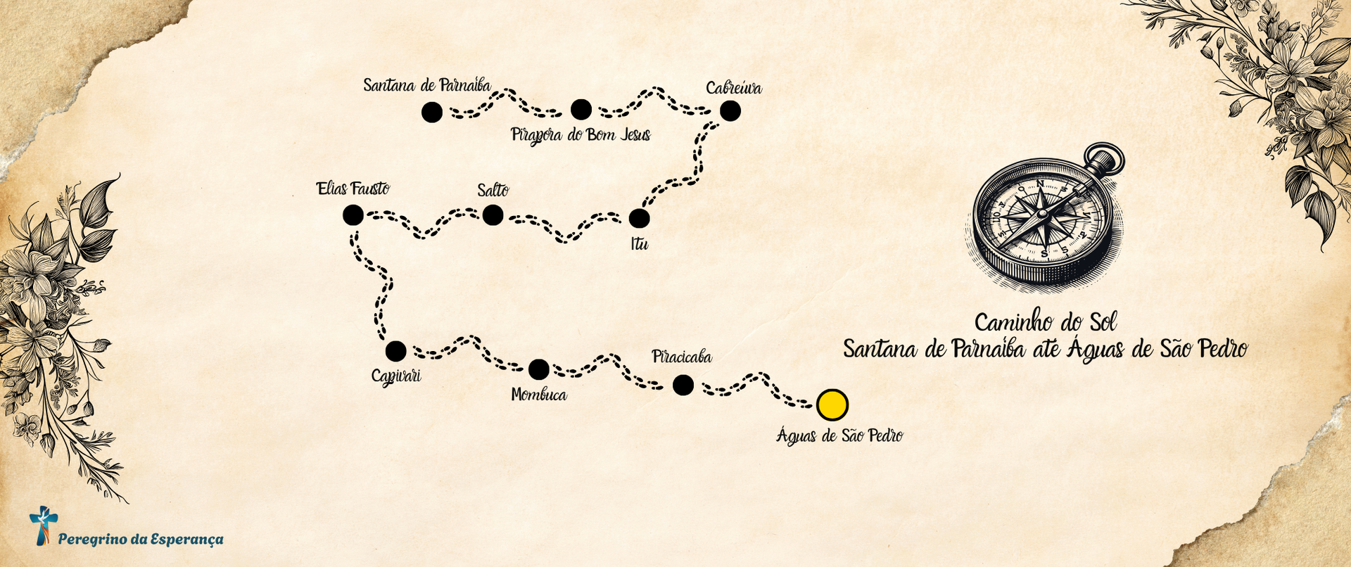
✨ Section 1 - Santana de Parnaíba to Pirapora do Bom Jesus
The initial stretch of the Caminho do Sol between Santana de Parnaíba and Pirapora do Bom Jesus covers approximately 15 kilometers and is considered to be of easy to moderate difficulty, ideal for pilgrims who are just starting out on their journey. The route runs along dirt roads and short stretches of asphalt, crossing urban and rural areas, with landscapes that alternate between historic houses and the typical vegetation of the southeast region of Brazil. The altitude is relatively gentle, with some slight ascents and descents, which favors a more relaxed walk, allowing the pilgrim to get used to the pace of the path and enjoy the spiritual and contemplative experience offered by the route. The climate throughout the year is predominantly tropical, with hot, rainy summers and mild, dry winters. Special care is recommended during the rainiest months, between November and March, when the ground can become slippery and require more care.
Leaving Santana de Parnaíba, pilgrims walk along cobbled streets and transition areas to the countryside, immersed in an environment that blends the old and the new, where the history of the interior of São Paulo begins to manifest itself. As they approach Pirapora do Bom Jesus, the landscape begins to reveal a more religious tone, marked by the presence of the Tietê River and the influence of the Sanctuary of Senhor Bom Jesus, an important point of regional devotion. This first stage of the Caminho do Sol, although not presenting great technical challenges, is rich in symbolic meaning, as it represents the beginning of the pilgrim's inner journey, marked by moments of introspection and contact with nature and local culture. The structure of the route is well signposted and offers safety, which makes it easier for hikers to adapt to the pace of the long pilgrimage that will follow until Águas de São Pedro.
✨ Section 2 - Pirapora do Bom Jesus to Cabreúva
The stretch of the Caminho do Sol between Pirapora do Bom Jesus and Cabreúva is approximately 22 kilometers long and has a moderate level of difficulty, requiring a little more physical fitness on the part of pilgrims. The route has variable altitudes, with steeper climbs and longer descents, which requires extra care on rainy days, when the ground becomes slippery. The route passes through forested areas, rural properties and dirt roads, offering a more immersive experience in the natural landscape of the interior of São Paulo. The region's tropical climate is characterized by hot and humid summers, especially between November and March, and drier and milder winters, which favors hiking between April and September, when the more stable weather reduces the difficulties on the route.
Upon leaving Pirapora do Bom Jesus, pilgrims leave behind the highly religious atmosphere of the local sanctuary and gradually enter more rural areas, where the silence and abundant vegetation provide moments of introspection and contemplation. During the journey to Cabreúva, the panoramic views provided by the natural elevations of the terrain stand out, as well as occasional support and rest points that offer a brief respite to hikers. Cabreúva, with its rural charm and welcoming atmosphere typical of small towns, marks the end of this stage with a peaceful environment conducive to recharging one's batteries. This section, in addition to requiring a slightly greater physical effort, also invites deeper reflection, being a significant stage from both a physical and spiritual point of view within the Caminho do Sol journey.
✨ Section 3 - Cabreúva to Itu
The stretch of the Caminho do Sol between Cabreúva and Itu is approximately 25 kilometers long and is considered moderate, with some long climbs and stretches of uneven terrain that require physical fitness and attention. The altitude varies along the route, with steeper inclines, especially when leaving urban areas and heading towards higher, rural areas. The route passes through dirt roads and short stretches of paved roads, crossing landscapes of secondary Atlantic forest, plantations and rural properties, creating an interesting contrast between nature and human interventions. The region's tropical climate accompanies the hike with high temperatures and greater humidity between November and March, and drier and milder weather from April to September, the latter being the best time for the crossing as it offers greater thermal comfort and a lower risk of rain.
Upon leaving Cabreúva, pilgrims enter a stretch that gradually distances themselves from the urban environment, immersing themselves in a landscape of open fields and interspersed forests, where silence and fresh air are constant companions. This stage invites an introspective walk, in which the physical effort required to overcome the inclines ends up becoming part of the spiritual process that the Caminho do Sol proposes. As they approach Itu, a city of historical and cultural importance in the interior of São Paulo, the landscape gradually becomes urbanized again, offering pilgrims a return to more intense human interaction, but without losing the welcoming and peaceful tone characteristic of the cities along the route. The stretch between Cabreúva and Itu, although physically demanding, provides a rich experience of connection with the interior of São Paulo, both through nature and the historical heritage that accompanies the route.
✨ Section 4 - Itu to Salto
The stretch of the Caminho do Sol between the cities of Itu and Salto is approximately 14 kilometers long and is considered an easy hike, making it one of the most accessible stages of the entire route. The altitude is predominantly flat, with small variations that do not require much physical effort, making it the ideal route for recovery after more demanding stretches. The trail passes through urban areas, rural roads and regions with riparian vegetation, especially near the Tietê River, which runs along part of the route. The climate throughout the year follows the typical tropical pattern of the interior of São Paulo, with hot, humid summers between November and March and mild, dry winters between April and September. The latter period is the best time for hiking, due to the lower incidence of rain and more pleasant temperatures.
Leaving Itu, with its remarkable historical heritage and welcoming atmosphere, the pilgrim heads towards Salto on a walk that, although short, is rich in symbolic and visual aspects. The stretch provides contact with the cultural legacy of the region, evidenced by churches, old mansions and urban landmarks that dialogue with the history of the bandeirantes and the formation of the interior of São Paulo. The arrival in Salto marks a smooth transition between two cities with a strong identity of their own, offering the walker opportunities for contemplation and rest without great physical challenges. Due to its ease and cultural richness, this stage is usually seen as a moment of lightness and renewal along the journey of the Caminho do Sol, allowing the pilgrim to walk more serenely, calmly observing the details of the surroundings and internalizing the meanings of the pilgrimage.
✨ Section 5 - Jump to Elias Fausto
The stretch of the Caminho do Sol between the cities of Salto and Elias Fausto is approximately 24 kilometers long and is moderately difficult, mainly due to the altitude, which increases as you leave the urban area. The route begins on flatter terrain, but gradually reveals long climbs and steep descents, requiring physical fitness and attention from pilgrims, especially during rainy periods. The route alternates between urban areas, dirt roads and rural stretches, where plantations, pastures and small forests predominate, creating a peaceful and varied landscape. The region's tropical climate provides hot and humid summers between November and March, with a greater risk of intense heat and storms, while the months of April to September offer milder and drier weather, ideal for hiking.
Upon leaving Salto, pilgrims soon notice a change in environment, exchanging the urban setting and city life for long stretches of nature and silence, where the predominant sound becomes that of the wind and birds. The journey towards Elias Fausto provides moments of introspection and connection with the slower, more contemplative rhythm of the interior of São Paulo. As the trail climbs and descends, the body is required, but the landscape compensates with wide views and an environment that inspires serenity. Arriving at Elias Fausto, with its peaceful, rural atmosphere, represents a point of physical and spiritual replenishment, ending one of the most remarkable stages of the Caminho do Sol, both for its natural beauty and for the feeling of gradually moving away from everyday urban life.
✨ Section 6 - Elias Fausto to Capivari
The stretch of the Caminho do Sol between Elias Fausto and Capivari is approximately 26 kilometers long and is classified as moderately difficult, with variable elevation that alternates between uphill and downhill stretches on dirt roads and rural roads. The hike requires extra care on rainy days, when the ground can be slippery, but it is generally quite accessible for pilgrims with intermediate physical fitness. The trail crosses open fields, plantations, small farms and areas of remaining forest, allowing hikers to immerse themselves in the typical landscapes of the interior of São Paulo. The region's tropical climate features hot, humid summers between November and March, with high temperatures and occasional rain, and drier, milder winters from April to September, the best time for this hike.
The departure of Elias Fausto marks the transition to one of the quietest and most introspective stages of the Caminho do Sol, where human presence is less frequent and nature seems to dominate the landscape. As the pilgrim advances towards Capivari, the pace of the path becomes more constant and the isolation of the rural areas favors moments of deep personal reflection. The broad horizons, the natural sounds and contact with the simple daily life of the farms along the route create an atmosphere of peace and retreat. The arrival in Capivari, a medium-sized city with more defined urban features, represents a gradual reconnection with daily life, but without breaking the serene spirit cultivated along the way. This stage, in addition to the physical challenge, also symbolizes the strengthening of the inner journey, becoming memorable both for the effort and for the landscape that accompanies it.
✨ Section 7 - Capivari to Mombuca
The stretch of the Caminho do Sol between Capivari and Mombuca is approximately 20 kilometers long and is considered to be an easy stretch, being a more relaxed stage from a physical point of view. The altitude is predominantly flat, with gentle variations that do not require great effort from pilgrims, which makes this route ideal for active rest after more demanding stages. The trail runs along rural roads and stretches of dirt, cutting through landscapes of extensive plantations, pastures and small areas of forest. The climate in the region is tropical, with hot and rainy summers between November and March, when the intense heat can make the walk more exhausting, and dry and mild winters from April to September, a more favorable time for the crossing due to pleasant temperatures and lower risk of rain.
Leaving Capivari, pilgrims soon enter a rural environment marked by the simplicity and silence of the farms and ranches that line the route. The tranquility of the stretch allows the walk to become almost meditative, with time and space to observe nature, the open sky and the serene rhythm of country life. Approaching Mombuca, a small and welcoming city in the interior of São Paulo, reinforces the feeling of passing through territories where time seems to follow a different rhythm than in large cities. This stage, although less physically challenging, offers a valuable opportunity to connect with the natural environment and with the inner experience of walking itself, and is remembered by many pilgrims as a moment of relief and emotional renewal throughout the journey.
✨ Section 8 - Mombuca to Piracicaba
The stretch of the Caminho do Sol between Mombuca and Piracicaba is approximately 28 kilometers long and is considered to be of moderate difficulty, requiring attention and physical fitness due to its length and the variation in altitude along the route. The route has uphill and downhill stretches, with gentler inclines and longer ones, especially when approaching higher areas. The hike takes place predominantly on dirt roads and rural roads that cut through agricultural fields, small forests and private properties, creating a landscape typical of the interior of São Paulo. The climate, typical of the tropical region, brings hot and humid summers, with frequent rains between November and March, while the months of April to September are marked by drier weather and milder temperatures, favoring a more comfortable crossing.
Leaving Mombuca, the pilgrim moves away from the bucolic and welcoming environment of the small town to enter a section that provides greater isolation and connection with nature. The landscape, marked by sugarcane plantations and areas of sparse vegetation, reinforces the rural and introspective character of the journey. As the route approaches Piracicaba, one of the largest cities on the route, the contrast between the quietness of the countryside and the urban movement becomes more evident, preparing the spirit of the walker for the transition. Arriving in Piracicaba represents not only the reunion with the more complex urban structure, but also an important milestone of the pilgrimage, symbolizing significant progress on the route and offering opportunities for rest, reflection and refueling before the next stages of the Caminho do Sol.
✨ Section 9 - Piracicaba to Waters of Saint Peter
The final stretch of the Caminho do Sol between Piracicaba and Águas de São Pedro is approximately 23 kilometers long and is considered to be of light to moderate difficulty, with gently undulating elevation and a few steep inclines. The trail passes through transition zones between the urban environment of Piracicaba and the tranquility of the rural area before arriving at the spa resort of Águas de São Pedro. Dirt roads, small woods and open fields make up the predominant landscape, allowing pilgrims to walk more fluidly and contemplatively. The region's climate, with tropical characteristics, offers hot and humid summers with rain between November and March, and drier and milder winters between April and September, the latter being the best time to complete the journey with greater thermal comfort and safety.
Leaving Piracicaba for Águas de São Pedro represents the symbolic beginning of the conclusion of the pilgrimage, in which the emotion begins to mix with the physical effort and introspection accumulated over the days of walking. The landscape, with its natural serenity, serves as the ideal setting for this conclusion, allowing the pilgrim to internally process the lessons and experiences lived during the journey. Arriving at the small and welcoming Águas de São Pedro, with its calm atmosphere and vocation focused on well-being and healing, represents not only the end of a geographical route, but also the outcome of an inner journey. Concluding the Caminho do Sol in this final stretch is, for many, a reunion with themselves, in which each step taken resonates as a symbol of overcoming, self-knowledge and spiritual renewal.